Offline map (PRO only)
Offline map is available only in GPX Viewer PRO.
The offline map is a map that can be used when the device is not connected to the internet, however, it also works when the device is connected to the internet. But you first need to download them to your device. GPX Viewer PRO currently support only offline map data which can be downloaded directly in GPX Viewer PRO, it does not support custom 3rd party offline map data as of yet. These offline map data are based on OpenStreetMap data. Basically, when you download some offline map data, in reality, you download raw vector, hillshade, and contours data for this offline map. These data need to be styled in order to be shown on the map. GPX Viewer PRO supports several offline map styles as shown in the screenshot below. Currently, it does not contain a style that is similar to the default OpenStreetMap map style, but we are working on adding this style to GPX Viewer PRO.
Here you can find the tutorial how to work with offline map in GPX Viewer PRO. If you encounter problems that downloaded data for the offline map are not shown, please refer to this help page.

Previews of offline map styles
Below you can preview offline map styles which are available in GPX Viewer PRO to use for showing offline map data.
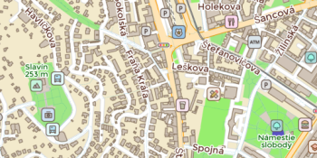 Basic
Basic
Most basic style with simple styling showing also points of interest. It allows the fastest rendering.
 Bubble Wrap
A full-featured city style loaded with helpful icons for points of interest.
 Cinnabar
City style with simple colors and points of interest.
 Raster
Is a style for showing user's custom raster data (jpg or png images) stored in MBTiles file format.
 Refill
A minimalist map style designed for data visualization overlays. Inspired by the seminal Toner style by Stamen Design. Refill supports multiple color themes.
 Street
Street style tries to mimic default OpenStreetMap style.
 Topo
Topo
Topographic style which tries to mimic OpenTopoMap style with contour lines.
 Tron
Tron
Will autonomous cars dream as they charge overnight? This style is pushing mapping to new extremes, and it will push your GPU and fan to the limit.
 Walkabout
This outdoor style is perfect for hiking or getting out and about, with mountains, ski trails, biking paths, and transit stops. Bike legend